11 December 2013

Saint Paul is first and foremost a river town. The Mississippi makes a great S curve through the western and southern stretches, isolating the West Side on its bluff and clutching the rest of the city in its sinuous curl. From our house, walking four miles in any of three directions (west, south or east) brings you to the river banks.
Yes, long stretches of those banks are shared with Minneapolis, but the enduring Twin Cities rivalry compels me to thumb my nose in that direction. Thus, for our purposes, the first evidence of civilization along the banks comes in the form of a sign: “SAINT PAUL/the Capital City/Desnoyer Park.” As we cross from Mill City to Capital City, another sign, embedded in a cut limestone wall, reads grandiloquently “Mississippi River Boulevard Parkway, Saint Paul, Minnesota.” To me, it’ll always be East River Road.
I looked back one final time at the bleak landscape behind me—the sterile towers, the fug of grain still clinging to the old mill sites, the sad diminished status of a city that was not the capital (yes, Minneapolis, I’m looking at you)—then turned and strode forward, keeping to the heights above the mighty river. Below was a hidden pathway along the river flats to Meeker Island, but this would end before the Marshall Avenue bridge. My destination lay far beyond.
Away from the river, an imposing string of stone houses—Georgian, Tudor, some Spanish touches—drowsed behind picture windows. Below on the right the river swooped beneath the line of trees that edge the bluff. Stretches of black iron fence outlined a decorative border and wooden benches set away from the path were aimed towards chosen views; home to amiable dalliances and half-dozing reminiscences. A memorial tablet here, a dip under the bridge there, and I was onto a long, rising stretch towards the Victorian mansions of Summit Avenue.
The hiker’s experience depends on weather and time of year. On fine weekends in summer, the path is thick with baby strollers, joggers, bikers and random sun-struck visitors being promenaded by hosts intent on correcting their flyover misconceptions. Pick a weekday at twilight, and the winding stones offer a day’s-end retreat for locals, grabbing an evening stroll before dinner. In December, the trees have been stripped bare, dark against the greying sky, and there’s a whip to the air. Far below the ice-chunked river still moves, but not for long. Only the occasional fresh air fiend or die-hard runner passes, bundled against the wind.

. . . Later, after circumventing the deep ravine west of Cretin Avenue, moving at cross purposes to the silent troops of University of St. Thomas students texting their way to class, I plunged on again, passing a beacon in the shape of a stone cross at the end of Summit Avenue, set on a promontory looking west across the river. I was in full stride now, with the pavement slapping the bottom of my boots, and the line of trees muting the sunlight slanting across my path.
Others had joined my perambulations—dog owners, ancient sun seekers, pairs of power walkers content to flail their arms high and exercise their lungs. Harsh Russian consonants came from an old couple seated on a park bench. Below us on the river, a barge moved downstream.
St. Mary’s Chapel and the St. Paul Seminary buildings fell away on my left. Daylight was fading. My path bent and curved along the bluffs. Over another ravine; past another memorial, this one recalling a drive-by shooting whose impact I remembered sadly: “Just a kid growing up.” South of St. Clair I passed the Temple of Aaron, with silent statues remembering lost loved ones set in the parkland opposite.
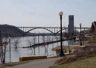
The road, the river, the path—all began to wind more and more. At Highland Parkway urban reality imposed itself again, in the form of the misplaced 740 Tower, the Ford Parkway bridge and, just beyond it, the empty remains of the now-shuttered Ford Plant. Not far beyond it is an overlook, and around a deep U-bowl ravine, the first of two access roads down to the legendary Hidden Falls.
Here we shall halt, where hikers face a vital decision: stay along the bluff all the way to Prior, where the second Hidden Falls access road descends opposite the Korean-congregant St. Andrew Kim Catholic Church, or face the fact that it’s the river’s edge one wants, and drop down immediately? That upper stretch has some of the highest bluff views available, and an almost palpable quiet, deep into the far reaches of Highland Park. But if it’s sanctuary one wants, better to descend to the river’s edge and double back north to Hidden Falls, or onwards, south and east past the Marina and into the watery marshes of Crosby Park and its cross-hatched forest trails.
Ah, but what of the rumors of a fort? Another river? Or even a long, bending watery curl that leads on to mighty bridges and landscapes heretofore un-described? Might the marble palace of the Central Library truly be accessed from the river side? It will take another journey to find out. . . .
The High Bridge links the West Side with the rest of St. Paul.
Despite repeated attempts, I have never completed a river hike to the end of Saint Paul, though I have reached the end of the blue metal railing that extends east from downtown and stood gazing upon the glowing spires of the water treatment plant below Mounds Park.